SeA-RVINS (latent) · TEX-CUP · approximately 20 km · 4,040 evaluation epochs · approximately 50% deep-urban driving
Robust estimation in urban canyons
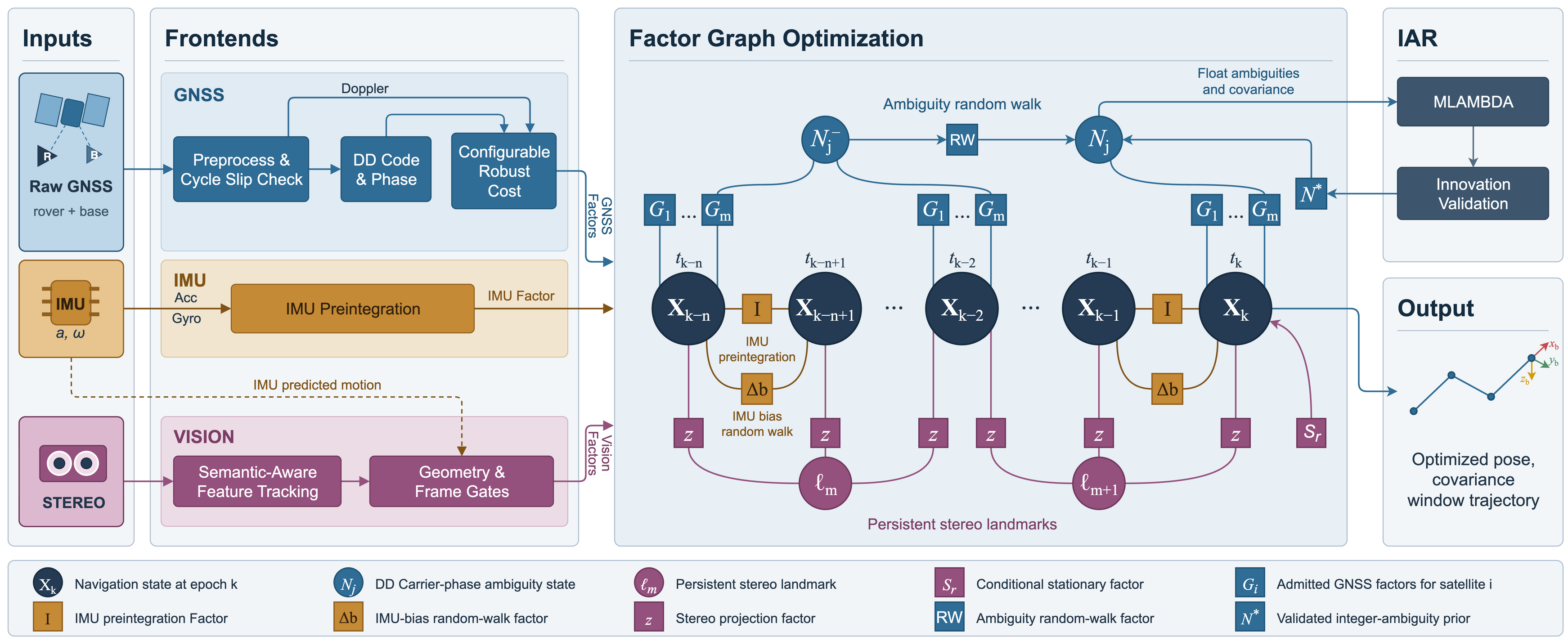
GNSS multipath, unreliable visual associations, and broken carrier-phase continuity can introduce errors that persist in tightly coupled estimators. SeA-RVINS addresses these sources of error in a fixed-lag factor graph that combines raw RTK GNSS, inertial measurements, and stereo vision.
A semantic-aware learned frontend screens tracks before they enter the graph. Three configurable robust formulations retain the shared-pivot correlation of double-differenced GNSS measurements. A hybrid ambiguity-continuation strategy shares ambiguity states over short, verified arcs and softly links successive arcs.
Reliable visual tracks
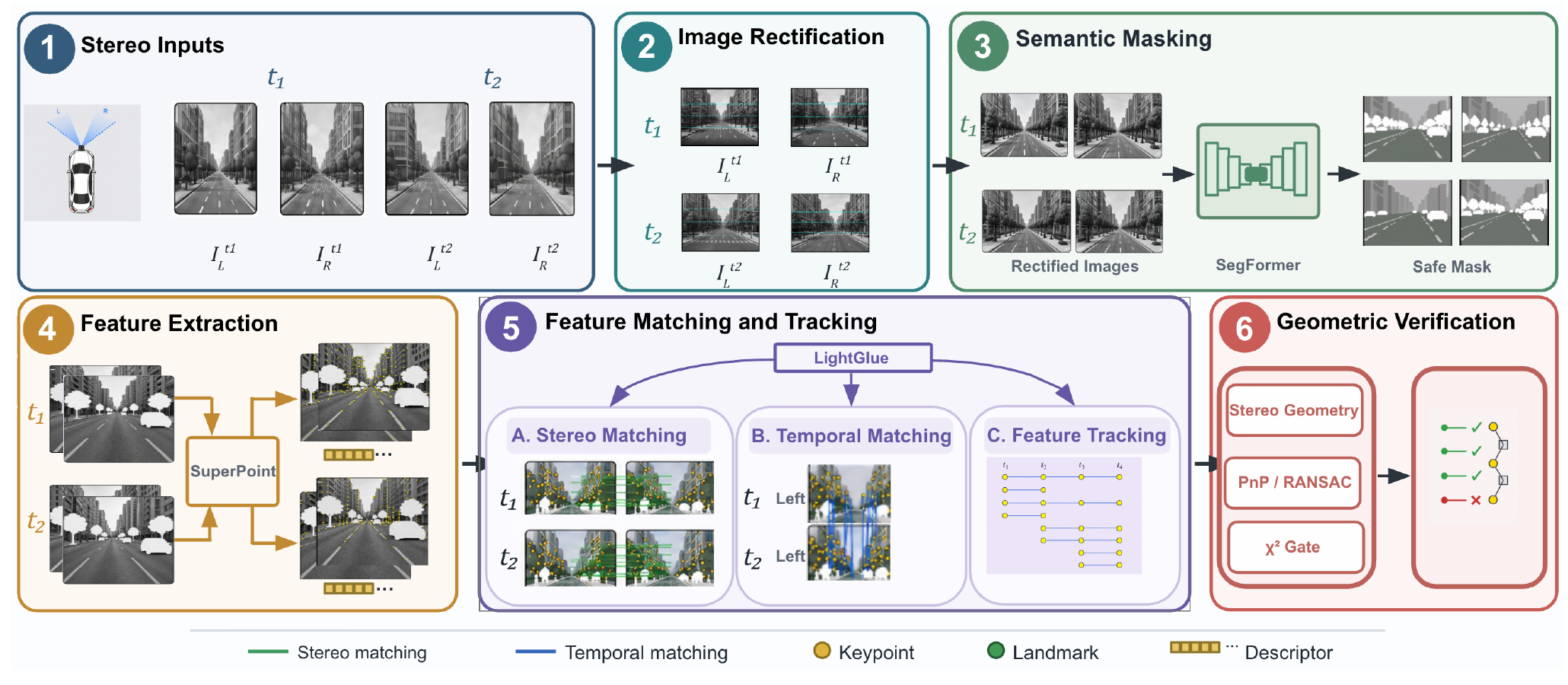
Semantic screening and geometric verification reject unreliable associations before they become persistent landmark factors.
Correlation-preserving robustness
Batch, scalar, and latent-pivot formulations apply Dynamic Covariance Scaling to double-differenced code and phase observations.
Verified ambiguity continuity
Bounded, continuity-verified arcs and random-walk links retain temporal information; broken or unverifiable continuity starts independent states.
Visualization example
Recorded visualization of SeA-RVINS (Scalar) results, showing semantic masking and visual feature tracking alongside the estimated pose and trajectory in a 3D map.
Interactive trajectories
Inspect the saved antenna-position estimates over the evaluated route. Toggle methods to compare tracks; gaps indicate unavailable solutions. Ground truth and SeA-RVINS (latent) are shown initially.
Loading trajectories…
Two-finger scroll or pinch to zoom. Drag to pan; right-drag to rotate and tilt, or use the sliders above.
OpenFreeMap streams OSM buildings as you navigate. Building heights provide visual context; trajectories show horizontal positions on the map, without estimated altitude.
Benchmark results
| Method | RMSE (m) ↓ | Maximum (m) ↓ | Below 1.0 m (%) ↑ | Below 1.5 m (%) ↑ | P95 (m) ↓ | Availability (%) ↑ |
|---|---|---|---|---|---|---|
| RTKLIB-EX | 4.95 | 58.56 | 46.14 | 59.23 | 8.41 | 100.0 |
| GICI-RTK | 4.69 | 177.00 | 77.60 | 87.43 | 5.70 | 96.7 |
| GICI-RRR | 92.44 | 1122.59 | 48.54 | 55.97 | 140.57 | 96.3 |
| VINS-Fusion | 5.10 | 35.86 | 44.26 | 57.82 | 9.68 | 99.9 |
| IC-GVINS (partial) | 7.68 | 30.47 | 9.16 | 14.31 | 21.95 | 37.2 |
| GVINS | 436.70 | >10,000 | 22.48 | 39.33 | 28.76 | 90.7 |
| InGVIO | >1,000 | >40,000 | 5.00 | 6.58 | 161.77 | 98.4 |
| OKVIS2-X | 19.29 | 69.44 | 31.29 | 44.98 | 50.17 | 100.0 |
| SeA-RVINS (batch) | 0.38 | 2.91 | 97.15 | 99.63 | 0.90 | 100.0 |
| SeA-RVINS (scalar) | 0.39 | 1.63 | 97.00 | 99.98 | 0.86 | 100.0 |
| SeA-RVINS (latent) | 0.39 | 1.60 | 96.16 | 99.90 | 0.90 | 100.0 |
Reading the results. Availability and threshold percentages use all 4,040 epochs; missing solutions count as unsuccessful. RMSE, maximum, and P95 use valid solutions only. Green bold values indicate the best value in each column. Arrows indicate the preferred direction.
IC-GVINS partial run. Only estimates before 18:35:00 UTC are retained (1,502 solved epochs); later epochs count as unavailable. This is a conservative pre-divergence reporting boundary, not an exact failure instant.
Comparison scope. Methods use the sensor configurations they support. Loosely coupled methods share RTKLIB-EX position inputs; GVINS and InGVIO use rover-only GNSS and serve as system-level references. See the manuscript for sensor configurations and 3D metrics.
| Method | Used-fix epochs | Fix rate (%) | Below 0.5 m (% of used fixes) | At least 0.5 m (epochs) | Horizontal RMSE (m) | Horizontal max. (m) |
|---|---|---|---|---|---|---|
| SeA-RVINS (batch) | 1,383 | 34.23 | 97.54 | 34 | 0.17 | 0.98 |
| SeA-RVINS (scalar) | 1,915 | 47.40 | 93.99 | 115 | 0.20 | 0.85 |
| SeA-RVINS (latent) | 1,842 | 45.59 | 99.35 | 12 | 0.15 | 0.55 |
A used-fix epoch applies an accepted integer solution. Fix rates use all 4,040 evaluation epochs; the remaining error statistics are conditional on used-fix epochs.
Benchmark methods & reproduction
The public TEX-CUP Urban-Navigation Benchmark provides data preparation, calibration, baseline run guides, and evaluation scripts, together with saved baseline and SeA-RVINS results.
System architecture
GNSS, IMU, and stereo observations enter a 6-second fixed-lag factor graph. Integer ambiguity hypotheses are validated before accepted fixes are applied.
Semantic-aware learned stereo frontend
Semantic masking, learned feature matching, and geometric checks screen stereo and temporal tracks before landmark admission.